Home » Rab Helvellyn Sky Ultra » The Course
COURSE START - 07.00am (Patterdale, Ullswater Valley)
MID WAY CUT OFF - 13:30pm (CP 5 - University of Cumbria)
KIRKSTONE CUT OFF - 15:00
SHORT ROUTE [THE BEACON CUT OFF] - 16:00
COURSE CLOSES - 20.30pm (Patterdale, Ullswater Valley)

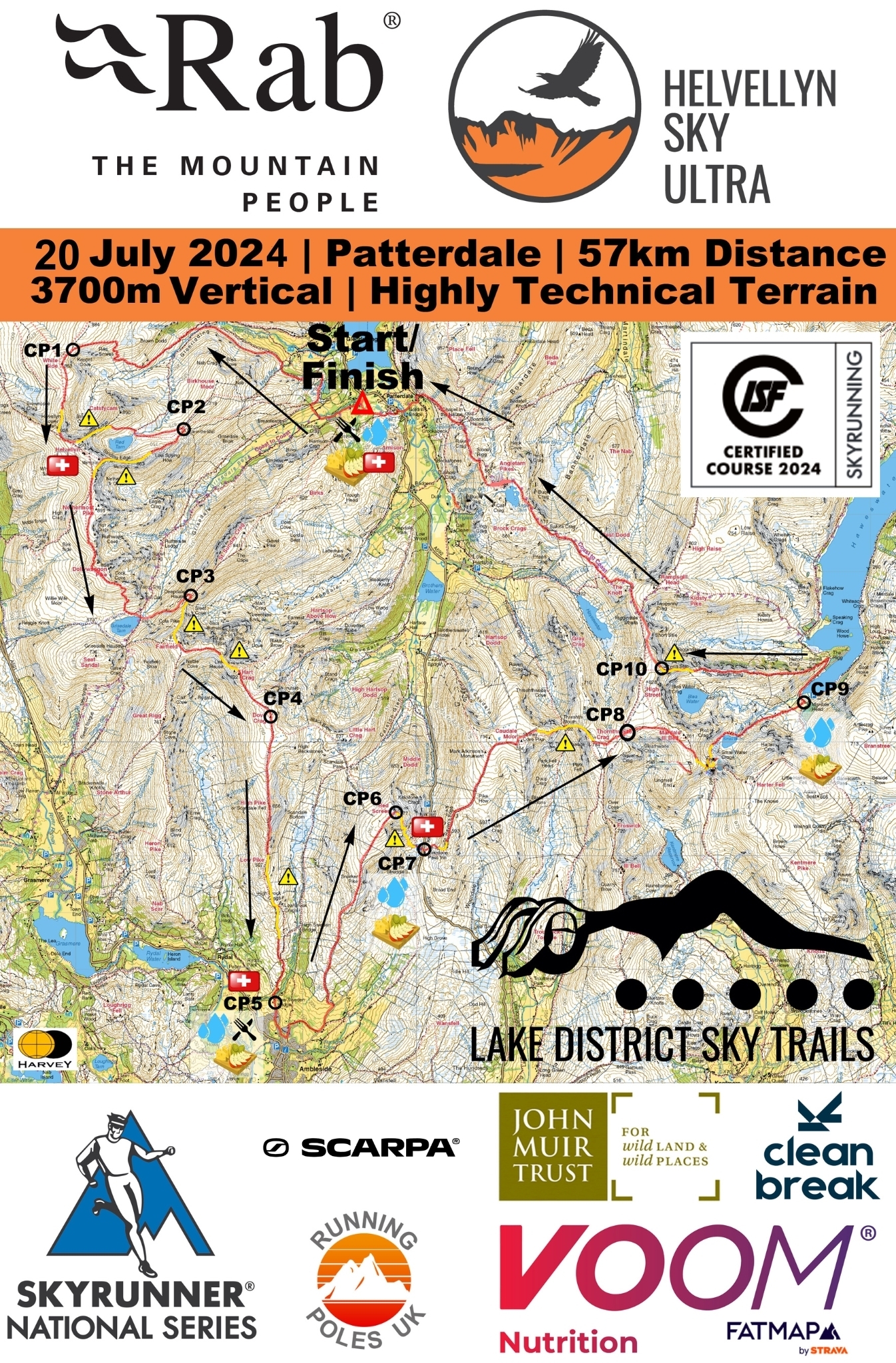
Helvellyn Sky Ultra provisional race route supplied for illustrative purposes only. Route amendments and updates may be made at the Race Director’s sole discretion. ©Harvey Map's 2024
Runners will start at 07.00am in Patterdale at the King George Playing Field, where you will head straight out into the Valley of Glenridding, via Grisedale and Lanty's Tarn.
A number of easy trails lead you to the zig-zag's of Whiteside and Raise, and then onto the first ridge-line of the day, the ascent of Lower Man. Next up is Helvellyn with a descent of the famous Swirral Edge, down to the Hole in the Wall and back along Striding Edge.
You head towards the rounded back of the Helvellyn Massif before the drop to Grisedale Tarn and the wonderfully technical ascent of Cofa Pike and onto the Fairfield Range. The descent from Dove Crag is fast and furious as you head to a to supplied checkpoint at Ambleside (CP 5).
You head back out to a long and tough ascent of Red Screes, then a quick drop into Kirkstone Pass before the next ridge-line is attained above St Raven's Edge. Rocky and technical drops into Threshthwaite Mouth, with glorious views around the head of Kentmere and then into the valley of Haweswater via Small Water, a hidden gem of the Eastern Fells.
Another tough ascent up Rough Crag and Long Stile Edge will see you almost on the summit of High Street before your long awaited final descent down back into the Patterdale valley via the Coast to Coast route and the finish line at the King George Playing Field!
Celebrations, a hot meal and a beer awaits you at Patterdale!
The route is fully marked and flagged, and whilst no navigational experience is required to follow the route, we highly recommend it as part of the race rules and regulations.
A safety team will be present on the hill for the full duration of the race, and there are marshalled control points at high-level locations along the course.
In cases of certain extreme conditions, we may have to enforce a reduced Bad Weather Route, designed with the safety of competitors and the race team in mind. The Bad Weather Route is at the Race Director’s sole discretion but has been designed to retain as much of the spirit of Helvellyn Sky Ultra™ as possible.
[Please Note: A deviation of the Bad Weather Route may be used in situations of inclement weather conditions to offer the best running again at the discretion of the Race Director]